
New Walk
This local walk doesn’t take you onto a mountain, but it is a local favourite and an easily accessible walk with beautiful views!
Time
2 hours
Directions
- Turn right out of the top of the campsite
- Follow the lane, and turn right at the sharp junction by the houses, and go down this lane to the main road
- Cross the main road and turn left once you have gone over the little bridge
- Follow the lane around to the right, ignoring the style on your left
- Follow this straight part of lane, and then go over the stile, in front of you, at the next junction (there will be a sign here that says no HGVs)
- Go into this field and cross the stream, that’s the other end of the field
- Walk through the next big sloping field towards to woods on your left, and cross the stream and then stile, into the little wood
- Make your way along the path going through the smaller field (where the hedge is on your left and stream is now on your right), and go over the stone wall stile
- Then continue up this hill, to the next gate
- Once you have reached the top of the hill, you will go through a green gate where there are built-in steps. Walk through this field and over the stile, into the farm OR Use the map here, and follow the fields and through the gates until you get to the farm Tre-gaig
- Continue through the farm until you see a rusted gate on your left
- Go over the stile here and down the field
- Follow the path, over the next stile
- Keep going down this field and over the stile that takes you opposite the house named ‘Tregaer’ where you will also meet the lane
- Turn left and onto the lane here and go along this lane for 1 mile (to know you’re on the correct track, you will pass a driveway called ‘Heddfan’ on your left)
- Follow this lane, ignoring any turnings
- Then keep going straight at the junction that you were at, at the start (there will be a sign here that says no HGVs)
- Go along this lane, and keep going straight ahead at the next junction
- Then, before the hill begins, there will be a footpath sign on your right Go over the stile here and into the field
NOTE: if you have a dog, please put it on a lead here as there may be sheep in the field
- Follow this path and go over the second stile. You will be able to see the lane and another bridge from here
- Walk towards the lane/bridge
- Cross the stile, and go over the bridge towards the Farmer’s Arms Pub
- Once you have crossed the road, you can either stop off at the pub, or turn right and the junction and follow the signs back to the campsite
We hope you enjoyed this local walk!

Tretower Walk
Tretower Walk
This local walk doesn’t take you onto a mountain, but it is a local favourite and an easily accessible walk with beautiful views!
Time
2 hours
Directions
- Turn right out of the top of the campsite
- Follow the lane, and turn right at the sharp junction by the houses, and go down this lane to the main road
- Cross the main road and turn left once you have gone over the little bridge
- Follow the lane around to the right, ignoring the style on your left
- Follow this straight part of lane, and then go over the stile, in front of you, at the next junction (there will be a sign here that says no HGVs)
- Go into this field and cross the stream, that’s the other end of the field
- Walk through the next big sloping field towards to woods on your left, and cross the stream and then stile, into the little wood
- Make your way along the path going through the smaller field (where the hedge is on your left and stream is now on your right), and go over the stone wall stile
- Then continue up this hill, to the next gate
- Once you have reached the top of the hill, you will go through a green gate where there are built-in steps. Walk through this field and over the stile, into the farm OR Use the map here, and follow the fields and through the gates until you get to the farm Tre-gaig
- Continue through the farm until you see a rusted gate on your left
- Go over the stile here and down the field
- Follow the path, over the next stile
- Keep going down this field and over the stile that takes you opposite the house named ‘Tregaer’ where you will also meet the lane
- Turn left and onto the lane here and go along this lane for 1 mile (to know you’re on the correct track, you will pass a driveway called ‘Heddfan’ on your left)
- Follow this lane, ignoring any turnings
- Then keep going straight at the junction that you were at, at the start (there will be a sign here that says no HGVs)
- Go along this lane, and keep going straight ahead at the next junction
- Then, before the hill begins, there will be a footpath sign on your right Go over the stile here and into the field
NOTE: if you have a dog, please put it on a lead here as there may be sheep in the field
- Follow this path and go over the second stile. You will be able to see the lane and another bridge from here
- Walk towards the lane/bridge
- Cross the stile, and go over the bridge towards the Farmer’s Arms Pub
- Once you have crossed the road, you can either stop off at the pub, or turn right and the junction and follow the signs back to the campsite
We hope you enjoyed this local walk!
Cwmdu Campsite walk – Crickhowell via the mountains
Cwmdu Campsite walk – Crickhowell via the mountains
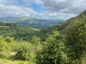
Crickhowell is a lovely little market town close to Cwmdu Campsite. Whilst it is only a 5 minute drive, it is possible to walk to by either following the River Usk or going up and over the mountains behind our campsite, following the Beacon Way. This mountain walk is a moderate walk with some steep sections, although as you follow the contours of Pen Cerrig-Calch, you have long stretches of flat walking with amazing views all the way across to Pen y Fan and its neighbouring mountains.

Cwmdu to Crickhowell Mountain Walk
Moderate Walk 6 Miles 2.5 Hours
- Walk to the top of the campsite and turn right. Walk along the road for approx. 200 metres before following the road around a left-hand bend and up the hill.
- At the top of the hill, go past the hay barn on your left until you reach a stonemason’s yard. Turn left here, walk through the yard, and go through the gate onto open ground.
- The track ascends steadily, and after a few minutes, you arrive at a metal gate with a stile next to it. Go through this gate and continue uphill following a deeply rutted tractor track. Follow the footpath way markers until you reach a mature larch tree plantation. Walk through this until you reach a stile in an old stone wall.
- After crossing the stile, turn right and follow the path, which will take you slightly uphill until you reach the Beacons Way sign. Continue straight along this path, following the Beacons Way signs on the southwestern slopes of Pen Cerrig-Calch.
- After approx. 1 mile you will see a stone cottage on your right, follow the Beacons Way footpath slightly left and up a steep hill. Continue straight following the clearly defined path.
- Continue your way along the Beacon way until you see a handwritten sign on a gate on your right-hand side, which says Crickhowell. Follow this path steadily downhill through some farms until you come to a quiet lane. Follow this lane downhill until you come to the A40 main road.
- Turn left and follow the footpath into Crickhowell, where there is a selection of lovely cafes, pubs and independent shops.
There are a few taxi companies to choose from if you decide not to walk back to the campsite. Table Taxis: 07939 287080, who allow dogs, are generally very reliable. Alternatively, the river walk back along the River Usk and through Tretower to the campsite is a gentle walk back.
Please remember to leave gates as you find them and keep dogs on lead if near livestock
Cwmdu Campsite walk – Crickhowell via the River Usk
Cwmdu Campsite walk – Crickhowell via the River Usk
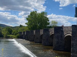
Crickhowell is a pretty little market town close to Cwmdu Campsite. Whilst it is only a 5-minute drive from Cwmdu Campsite, it is possible to walk to it either by following the River Usk or by going up and over the mountains behind our campsite, following the Beacon Way. The route detailed here is a relatively flat walk that takes you from our campsite, past Tretower Castle, and along the River Usk into Crickhowell.
Cwmdu to Crickhowell River Walk
7 km 1.5 hours (no hills!)
- From the top of the campsite, follow the lane to the right, continuing in a straight line past the cottage at the furthest corner of the campsite and then straight ahead down the green lane.
- At the end of the track, turn left; you will have to walk down the main road for just under 300 metres before taking a footpath along the pavement through the small village of Tretower. Turn right off the main road heading towards Tretower Court and Castle.
- Walk directly past the main entrance to Tretower Court and continue straight along the quiet lane.
- Just 100 metres later, you cross a small river and 210 metres after that cross a second very small stream. Turn immediately left after the little stream, following the waymark fingerpost which points down the side of a large field. This leads to a stile which takes you into a narrow strip of woodland where the path is easy and obvious.
- Eventually this returns you into the large field, and it’s just a couple of hundred metres further to reach the main road (A40). Please note the route where you entered the large field, as on the return the entry point to the woodland strip isn’t quite so obvious.
- At the A40, turn left and follow the wide grass verge down to the Glanusk Estate gates on your right (approx. 150 metres). Here, despite the first impression that you are not allowed in, you gain access to the “Permitted Path”. Walk through the gate and along the road directly towards the fine “castle-like” tower that you can see in front of you. Immediately before the bridge itself, turn left. Do not cross the river.
- Walk across the grass and just 30 metres later cross a footbridge with a metal gate at the far side. Then follow the obvious path directly alongside the river Usk all the way down to Crickhowell.
Please remember to leave gates as you find them and keep dogs on lead if near livestock.
